Tamkeen

Irrigation Management

1- Planning/Scheduling, Based on Actual Water Use & ET.
2- Monitoring, Daily Imaging the Water Features.
3- Cost Effectiveness, Water Optimizing According to Crop Growth.
4- Reporting.

Crop Health Management

1- Monitoring Crop Growth, Reducing Non-Uniformity.
2- Detecting Crop Diseases Timely.
3- Cost Effectiveness, Nutrients Optimizing According to Crop Growth.
4- Reporting.

Crop Yield Prediction

1- Monitoring the Daily Growth Obtained.
2- Giving the Chance to Modify the Crop Program.
3- Having Estimated Yield & Production 4-6 weeks Before the Harvest.
4-Cumulative Growth Evaluation.

Supply Chain Toolkits

1- Soil/Area Mapping for Precise Actual Planting Area to Verify the Contracted Planted Area.
2- Potential Yield & Production Prediction.
3- Identify the Mature Fields Independently.

Tamkeen - 'k' letter

What we’re offering

The root of effective irrigation

Irrigation can be optimized using technologies.
IrriWatch helps farmers and their irrigators to optimize irrigation water applications in a world of dynamical weather, soil and crop processes. The soil moisture and evapotranspiration of every pixel of 10 m x 10 m is measured daily from satellites for capturing the variabilities of key processes in space and time. Actual crop evapotranspiration from IrriWatch-offers an alternative to the classical Kc x ET0 approach that for more than 50 years has been used for computing crop water requirements. Almost all current irrigation advisory systems are based on automated weather stations for ET0 and a tabular crop coefficient Kc. IrriWatch is going to change these simplified approximations.

Based on a recurrent data subscription system, IrriWatch provides soil moisture-based irrigation scheduling. IrriWatch is meant for on-demand irrigation systems, such as tubewells, pressurized distribution systems and canals with continuous flow. It deals with micro-irrigation and flood irrigation systems. An Irrigation App provides a suggestion for tomorrow’s irrigation schedule for every field or part of a field. A web-application shows a helicopter view of all fields from today, and the past. Today’s satellite measurement of the soil and crop status is integrated with tomorrow’s weather forecast. IrriWatch matches water supply and water demand that leads to a fair, profitable and sustainable agro-ecosystem.

Tamkeen - 'k' letter

We use existing and new technology

We use three components to reach our goals

Measurements of different thermal satellites are combined into a daily leaf temperature product from which evaporative cooling, sap-flow, and root zone soil moisture conditions are inferred using advanced remote sensing algorithms. The soil moisture from today – in conjunction with weather forecasts for tomorrow – will assess the need to irrigate during the next 24 hours.  IrriWatch is the only company using the 4th generation SEBAL model as the core engine.  Every field is divided into pixels of 100 m2 each. For each hectare (10,000 m2),  100 pixels will be consulted to decide on required irrigation actions for tomorrow.  Irrigation is advised if 20 to 40 % of the pixels have soil moisture that is lower than the so-called critical soil moisture (i.e. threshold value at which crop water stress is triggered)

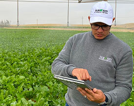
Advice with a certain minimum and maximum amount of irrigation water is provided via the IrriWatch App that is freely downloadable from the PlayStore and the AppStore. Fields requiring water will be highlighted on a map. In this case irrigation is not required, the remaining period until the next irrigation is provided. For orders with less than 25 fields, each field will have a personalized Irrigation Bulletin. The priority of the fields to be irrigated will be ranked every day so that irrigation teams in the field better know where to start their job after checking the App at the breakfast table.

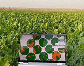
The service includes also a web application for your tablet or laptop for additional diagnostic analysis. We provide a spatial viewer for commercial users who manage farms in different parts of a given country (or in different countries). This viewer is a monitor of the daily irrigation processes of all fields. Whether you call this a “monitor” or “control room” is your decision. We offer you the technology to oversee all fields you are responsible for. Areas of particular interest can be seamlessly zoomed in and out. This can be especially valuable in irrigation water supply systems that lack adequate and reliable flow measurement capability. Water supply agencies can monitor the equitability of water distribution and water productivity using unbiased information from IrriWatch.